Sunday, February 28, 2010

Precision Approaches – Just the Facts, Ma’m


If you try and explain precision approaches in sentence form you can write for days. The nuances of ILS approaches or approach plates can fog the brain with minutia. My problem with these complex subjects is that the books or articles you read rarely just summarize the important data to help simplify the review of the subject. 


The following is a fact summary I have compiled from many different sources. The limitation to this summary for others is that I have only VOR approach capability. I do not have an IFR GPS or even a DME unit. Therefore, specific issues related to these approaches will not be contained in this list.

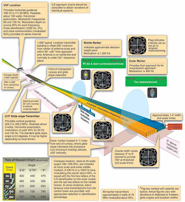
The Five Parts of a Localizer Approach
Localizer
Glide slope
Threshold crossing height
Outer marker
Middle marker

LOM: Locator Outer Marker - approx. 5 miles from the runway

LMM: Locator Middle Marker - approx. 1/2 mile from threshold and at about where the glideslope intersects decision height.

Localizer identifier always begins with "I" (dot dot) and frequencies are always on "odd tenths" - e.g. 108.1, 108.15, 108.3, 108.35

Localizer signal is 700 feet wide at threshold

If Nav receiver has 5 dots then each dot equals 300 feet at the outer marker

Needle readings may be unreliable more than 35 degrees from the course

Localizer is aligned within 3 degrees of runway centerline

Glideslope:
If followed to touchdown an aircraft would touch down on the fixed distance marker 1000 feet from the threshold
- the GS signal is not usable all the way to touch down. It becomes
unusable 18 to 27 feet above the ground
- signal is typically transmitted at a 3 degree angle
- at the outer marker the signal is approx 50 feet per dot
- it is common sense to fly at or above the glideslope as not much terrain clearance is provided
- on a bumpy day consider flying one dot high
- the MAP on a precision approach is called Decision Altitude (DA)
- on the marker beacon a " high" setting means reception over a greater area and less precise position identification. Normally set to low position. Turn up volume.
- the outer and middle marker beacons provide range information but neither is required for the approach. The outer marker is located at the approx. point where the glideslope intersects the intermediate approach altitude however it should not he treated as the final approach fix. Descent begins at the glideslope intercept point.
-         the outer marker flashes blue and emits dots at 120 dashes per minute. It intercepts the glideslope at the intermediate approach altitude – however it is not the final approach fix.
-         the middle marker flashes amber and emits dots AND dashes at 95 of each per minute. It is located approximately where the decision altitude is reached, although it is not used to identify the missed approach point.
-         The inner marker flashes white at a rate of 360 dots per minute and is located near the runway threshold
-         when decision altitude is reached there is no leveling off. Either you see the runway environment or you immediately begin the missed approach.
-         You can help verify the glideslope signal by comparing the crossing altitude at the outer marker with the altitude shown on the approach plate. A discrepancy means either a false glideslope signal, a malfunctioning glideslope receiver or the altimeter is incorrectly set.
-         The HAT, or Height Above Touchdown, are shown in small numbers after the MDA’s and DH’s in the minimum sections of the approach plate ie: 222/24 200. In this case the TDZE (touch down zone elevation) is 22 feet so the HAT is 200 feet.
-         TCH – threshold crossing height: The height above the runway where the glideslope intersects.

There are three categories of precision approaches:

Category 1: provides height above touchdown of not less than 200 feet

Category 2: provides height above touchdown of not less than 100 feet
Category 3: has no decision height

How To Intercept and Track The Localizer


Friday, February 26, 2010

Night Flight to Sacramento International (or: Three Legs, Three Serious Mistakes)


I recently flew a 3-leg flight from Santa Rosa to Sacramento, then on to Napa and finally back to Santa Rosa. The first leg would be flown at dusk. The last two legs would be at night. A waxing-crescent moon would help illuminate the way over California’s Sacramento Valley and the Napa wine country.

It had been a beautiful, uneventful, flight as I arrive at the outskirts of Sacramento International, call sign “Capitol Tower”.


The view over the Sacramento Valley at dusk enroute to Sacramento International.

Leg 1
"Cardinal 34777 do you have the airport in sight?" asked the tower controller.

Well, I thought I did.  Then, as my scan rotated out the left side window I notice two long and brightly lit runways disappearing behind my left wing tip. They look suspiciously like Sacramento International runways 34 Right and 34 Left.

Crap! Not only is this a rather large airport handling rather large aircraft, it is also sitting out in a field all by itself. How the hell did I miss those two huge parallel runways?

"I do NOW, " I emphasize to the controller, letting her know I realize I screwed up.

Not only have I missed runway 34 Left, I have already passed 34 Right! It will take a 135 turn to get back to 34 Left. Making sure the controller wouldn't prefer me to come in on the closer runway I ask,

"Capitol tower, confirm you want me on 34 Left?"
"If you can make it," she says in an accommodating manner.
" Willco, 34777."

So, where did I go wrong?

First, I had never been to the airport before and now I was trying to find it in the deceptive light of dusk.

Secondly, I had assumed that since it was such a large airport, I would have no problem finding it.

Lastly, I became fixated on a set of lights in the distance that I assumed must be the airport. Yet a quick glance at either my (very basic) GPS or out my left window would have revealed the two large runways clearly in sight.

  The lights I thought were KSMF are in the upper right of the photo. In fact, KSMF was off to the left of this photo (out of the picture).

Lessons Learned #1
  • When flying to an unfamiliar airport, even one you think will be easy to locate, view the airport and surrounding terrain on Google Earth prior to the flight and identify recognizable landmarks as reference points.
  • At an unfamiliar airport don't hesitate to let the tower know you are unfamiliar and ask for guidance. They are usually more than happy to help.
  • Try to avoid fixation on a point that you think is the airport if you are unsure - keep scanning and review the heading indication on the GPS.


    FINALLY, lined up for 34 Left!


    Leg 2
    Continuing my three-leg trip, it was full dark when I was ready to depart KSMF (Sacramento International) for APC, another short twenty-minute flight. The plan called for me to do a full stop at Napa and then return to Santa Rosa.

    It was here that I was to make the first of two identical mistakes. Even though I had my Iphone in my pocket I did not take the time to get an updated weather report for APC.

    I could either have called the ASOS  (which I had on speed dial) or I could have pulled up an Iphone application that would have instantly given me the info. Either effort would have taken no more than a minute or two. Instead, I chose to launch into the dark night (that held a real possibility of fog and clouds) without getting a weather update.

    Perhaps I was thinking that the moonlight would help me see any problems. That may have worked if there was only a single layer of clouds and fog. However, there was a thin overcast layer up in the flight levels that did not allow for full illumination usually associated with full moon on a clear night. 

    I repeated the same mistake at Napa prior to taking off for Santa Rosa.

    This is what is known as poor aeronautical decision making (ADM). In fact, it is the worst kind of ADM. It is the kind of decision-making that makes NTSB reports. It can leave loved ones wondering how such a thing could have happened, when they hear about your fatal accident.

    The National Transportation and Safety Board conclusion would read, "VFR flight into IMC with subsequent loss of control. There were no survivors."

    The NTSB records have thousands of similar reports. Other pilots would posthumously chastise me for my stupidity and mourn the loss of a good aircraft.

    This HAS to be the kind of mistake that, if you are lucky enough to survive it the first time, you absolutely cannot repeat it again. Writing this account down is my way of burning the mistake in my brain so that I do not forget it. Only time will tell if it has the desired effect.

    To my mind, if I don't recognize and try and correct the mistake, I will plant a small seed that grows into a future decision. "Well, I got away with it THAT time, so I'll probably get away with it this time."

    Lessons Learned #2
    • Always, always, get an updated weather briefing before departing each leg of a multi-leg flight. It is so easy with an Internet capable phone that there is no reason not to. This is especially true if the flights occur at night.
    •  Even a full moon and unlimited visibility at night is no guarantee of illumination if there is a thin cirrus layer that thickens during the flight. 
    • Aeronautical decision making for night flights must take into account the added risk factors. You cannot assume that a decision that is acceptable for a day flight will provide enough margin for error for a night flight.
    • A VFR night flight can turn into an IMC flight very quickly if clouds or fog are encountered.

    Leg 3
    Approaching STS after the tower closed seemed like a simple process. The visibility was perfect, there was no traffic And no wind. Even I couldn't screw this up, right?

    Wrong.

    The tower had just closed and I thought it was kind of cool that the busy airport, that always required communication with the tower, was now an uncontrolled field.

    The airwaves were silent and so the entire airport and runway were all mine. Mostly because I could, I clicked the mic button seven times and watched in awe as the massive MALSR lighting system went to full bright.

    With the airport glowing like downtown Las Vegas, I wouldn’t have to worry about missing this runway, I thought.

    I called on the CTAF that I was entering the right 45 for runway 14. A few moments later I called right downwind for 14 and then the base turn to 14. 

    Then I noticed the ILS lighting below me, which you will remember, I had recently turned up. Slowly the realization that Runway 14 doesn't have an ILS crawled out of the dark space of my mind.

    "Uhhh, 777 is turning final for runway 32,” I say extra loud, “Repeat, Triple 7 is turning final for runway 32, not 14, at Santa Rosa.”

    Dohh!!!

    Lessons Learned #3 
    • This seems to be a mistake that I continue to make over and over again. Mis-identifying runways is perhaps understandable for new pilots but there shouldn’t be any excuse for experienced pilots. I am going to add a new item to my airport approach checklist – “Runway verification? – Check.” 

    Learning Lessons
    I have learned that there is no such thing as a perfect flight. Every single flight I make will have some mistakes. Some will be minor and some will have the potential for a deadly outcome.

    Most serious accidents are the result of a chain of events.

    Something small goes wrong with the aircraft or the flight. Next, the pilot makes a small mistake. So far the minor issues are manageable. No problem, just fly the plane, says the pilot to himself.

    Then one more thing happens that, when combined with the earlier issues, suddenly presents a very serious problem. Link number three in the accident chain has just occurred. Now the outcome of the flight is no longer certain.

    In order to reduce the number of possible links in an accident chain, pilots must continuously and proactively strive for perfection. While it may, theoretically, be an impossible goal, every lesson learned is one less link in your next accident chain.

    Gary

    Sunday, February 21, 2010

    Time In The Clouds

    I've feared it, been fascinated by it, but mostly I've been curious about it. What would it really be like to fly a plane in the clouds for an extended period of time?

    Yesterday I found out.

    According to my instructor it was a "mild" IFR day. It was overcast at 1100 feet for many miles in every direction. The visibility was around six miles.

    There was a stable air mass over northern California with light winds and little or no rain. The temperature at our proposed cruising altitude of 6000 feet was 2 deg. Celsius, so we would need to keep an eye out for ice. Prior to takeoff we had no idea where the tops of the clouds would be.


    This was the sky prior to takeoff.

    Normally I hate overcast skies but on this morning they had me grinning like a Cheshire cat. I would finally get a chance to fly in some real clouds!

    The flight would depart from Santa Rosa (STS) to Sacramento Executive Airport (SAC). We would, hopefully, shoot the ILS Rwy 2 approach then probably go missed and return to STS.

    I attempted to file two flight plans online with AOPA Internet Flight Planner. I had done this before with no problem at all.

    This time I had problems. I wasn't sure how to file the route and I screwed up the first filed flight plan. Then it wouldn't let me delete the screwed up one and replace it with a correct one. ARGHHH! Then I tried to file the second flight plan (SAC to STS) and made another mistake here. Again, I had the same problem in that it wouldn't let me re-file a corrected plan. Now I had two screwed up flight plans filed with Flight Service.

    I got further stressed knowing I was going to have to confess to my instructor that I wasn't even capable of filing a simple flight plan.

    In retrospect, I got very stressed out over what was a simple and easily correctable problem. I mention it here because I need to learn not to let such a small issue affect my mental state. So - mental note - "It is very important not to let small, correctable, issues add to your stress level before a flight".  

    The planned route to SAC in flight plan format was: 

    Frees6.STS V459 SAC

    These hieroglyphics translate into:

    Depart Santa Rosa Airport - via the Frees6 Departure - back to the STS VOR - V459 airway - to the SAC VOR - land Sacramento Executive Airport.

    I met my instructor at the FBO and I confessed my filed flight plans were screwed up. He suggested I call Flight Service and see if I could get it straightened out. I called 1-800 WX Brief and the briefer was very nice about correcting the problems. He didn't make me feel like an idiot and I appreciated his attitude.

    Shortly thereafter we climbed in the plane, did the checks and called ground control. I asked if they had my IFR flight plan and then said they would check. A few seconds later they came back and said,

    "34777 we have your clearance, advise when ready to copy."

    With pencil in hand and paper in lap I say, "Go ahead, we're ready to copy."

    The ground controller reads the clearance and I was pleased that I was able to keep up and write everything down. However, he had given us a departure procedure (DP) I couldn't accept (DME required which I didn't have).

    I started to mention that we needed the Frees6 departure when my flight instructor interrupted me.

    "Always read back the clearance first, then explain any issues with it", he says.

    I read back the clearance and then ask for the alternate DP. The controller says "stand by" and we wait for just a couple of minutes before receiving the amended clearance.

    We do our VOR accuracy check in the run-up area and with the DP in my lap, NAV and COM radios and OBS's set and heading bug adjusted for my first course, we're cleared for take-off.

    At 1100 feet we enter the clouds. Even though I wasn't wearing the view-limiting foggles today I barely noticed the transition. I was still in a climb and I was focused on the instruments.

    Finally, I lift my eyes for a quick peak. The view was solid grey/white and somewhat disconcerting. Then the "leans" set in.

    The "leans" is the over-whelming sense that your body, and hence the plane, is most definitely in a significant bank. You get a strong urge to roll yourself and the plane "level". This, of course, would be a mistake since you aren't in a bank at all. It is the fluid movement in your inner ear that is telling your brain something that isn't true.

    A check of the attitude and heading indicator verifies that you are straight and level but it takes some self-control not to get distracted by the feeling. Eventually it goes away, only to return at various stages through-out the flight.

    We continue to climb up in the cloud layer and I start to feel more comfortable with the concept that I can't see out the window. At this point I am glad I have a good idea in my mind of where we are, where we are going and how we're going to get there. We have only basic VOR and associated "steam" gauges. There is no fancy GPS in 34777. We do have a 15 year old, three-inch round, Apollo 360 GPS which does help with situational awareness, but not much else.

    After climbing in the clouds for almost 3000 feet we break out into clear blue sky. Again, I don't really notice except that it's much brighter in the cockpit all of a sudden. We're almost at Frees intersection and there is no time for even a quick peek outside.


    After making the 180 degree turn at Frees and getting established on the inbound course to STS VOR, I finally take a quick look out the window.

    Oh-my-freaking-gawd it is beautiful!

    The gloomy, overcast day has magically turned into the brightest, sunniest, blue-est day ever! Below us is a solid and brilliantly white rolling layer of unbroken cotton that stretches as far as the eye can see.

    The grin stayed on my face for a long time. In fact, I think it's still there.

    We now had about 20 minutes of flight time before we would need to begin the set-up for the SAC approach. I really hadn't had such an IFR "quiet time" up until now. My previous flights had always been the rushed, procedure-to-procedure affair, that left no time to just fly the plane quietly. In reality, this is probably much more what a real IFR flight is like and I definitely enjoyed the time. 

    All to soon ATC begins vectoring us to the ILS 2 localizer approach to Sacramento Executive Airport. Then we are told to descend to 2000 feet.

    As we enter the clouds the turbulence becomes a little freaky. It is much stronger than our climb-out at STS. We're bouncing around and the damn "leans" set in again. I also, perhaps for the first time, begin to truly appreciate the ground. Perhaps I should say, FEAR the ground. As we descend through the clouds the realization that I am truly trusting my life to the instruments becomes very real. I try to put the thought out of  my mind and focus on flying the plane.

    We intercept the localizer and I do an ok job of flying down the chute. We break out around 1000 feet and are cleared down to 700 by the tower and instructed to circle to land on runway 20. This was kind of new to me since I've never set up for a landing from 700 feet. I did all the normal stuff and the landing turned out fine.

    My instructor needed to make a pee stop so we parking at the terminal building, did our thing and were soon on our way back to STS.

    The flight was a confidence booster in that I felt that I had a good grasp of where I was, what I was doing and how to go about it.

    Lessons Learned:
    • If there is a problem with the clearance, first read it back and then state the problem
    • Add wind direction and speed to my take-off checklist and memorize 
    • Add intermediate fixes to flight plan to verify wind and fuel consumption
    • File IFR flight plans on airways (if you don't have an IFR GPS)
    • Review alternate requirements (1-1-2-3: from one hour before to none hour after, 2000 foot ceiling, 3 miles visibility) and file an alternate if required - or even if conditions are close to requiring an alternate, since they may deteriorate.
    • Don't get stressed out over small stuff before a flight
    • Set up all the NAV and Com radios ahead of time. Use NAV 2 to aid with situational awareness if not otherwise required.
    • Have a heading and plan in mind for engine failure when flying on top of a solid cloud layer (know where the ridges or mountains may be hidden in the clouds below)
    • Double check your flight plans carefully before submitting them.
    Gary

    Sunday, February 14, 2010

    Weather: Beyond the Clear-Air-Visibility-Unlimited Pilot

    I've flown for twenty years as a very safe pilot. I know this because, well, not very much ever went wrong.

    The other reason I know this is because during all that time I only flew when the weather was CAVU. In addition, I rarely flew farther than an hour from my home airport.

    In all that time I never came close to running out of fuel nor did I have a close call with instrument meteorological conditions.

    My flying experience was the result of a number of factors.The first was cost. I rarely had enough money to pay for more than a two hour flight.Secondly, I was renting aircraft and the scheduling problems and other limitations made it difficult to take a plane for a weekend trip.

    Lastly, I was afraid. I was terrified of dying in an airplane crash.

    Very early in my flight training I came face to face with the harsh reality of death in general aviation. Over a period of 18 months, during my private pilot flight training, seven people I knew died in five separate crashes.

    Many years have passed and I now know that what I experienced was a statistical anomaly. At the time, however, I believed this frequent personal connection with flying and death was normal. I regularly read the NTSB reports and they seemed to confirm my conclusion.

    I kept flying in the wake of all this death because every accident had been a result of weather or stupidity. In one case it was a combination of both. I simply told myself that as long as I avoided weather I would reduce my chances of dying significantly.

    Trying to avoid doing something stupid was a little harder. There is so much to learn about flying that sometimes you don't know something is stupid until you've done it. Combine this with someone who has long history of stupidity, and this could be a problem for me.

    Now, I am in the early stages of instrument flight training and am also a partner in a Cessna Cardinal.The IFR training has caused me to spend time learning about weather in much greater detail. The Cardinal has allowed me to take trips to places I wouldn't have dreamed of before. These two factors have clearly raised my chances of becoming another NTSB statistic.

    So why the hell do it? Why not just keep piddling around in the airport's backyard on those calm summer afternoons? In this way I will drastically reduce my chances of something bad happening to me in an airplane.

    The answer for me is, adventure. I want to go to distant and new places and see and experience the amazing world beyond my horizon. I don't know how I got this way and it probably doesn't matter.

    As a result of my new knowledge, Linda and I made a flight yesterday that I would not have contemplated a year ago.

    The flight was a short, two-leg from STS (Santa Rosa) to APC (Napa) to CCR (Concord). The stop in Napa was for Linda to handle a notary signing. At Concord we would play the nine-hole golf course next to the airport.

    The weather forecasts the night before the flight suggested marginal conditions. Possible fog and broken to scattered low clouds. The temperature would be a balmy 60 degrees and the winds were forecast calm. A year ago I would have ended my hope for the flight the night before. A lot of clouds in the sky meant I wasn't flying. Now however, the flight was a "maybe".

    I woke early on Saturday morning to clear skies over Cloverdale. While this was a good sign, I knew conditions at STS could be quite different. They were. Santa Rosa was LIFR with haze and two layers of low clouds. A quick check of surrounding airports, including Concord revealed some hope for the flight. Concord was CAVU. Napa was scattered at 1100. The central California valley was also CAVU. The STS forecast was improving to VFR by 11 am.

    Now the flight had gone from a "maybe" to a "probable" assuming the forecast was correct. So Linda and I packed up our stuff and headed for the airport. 

    At this point I did have doubts, and not just about the weather. Was I making an intelligent and considered analysis here, or was I just being stupid for trying to make this flight? What if things got worse once we were in the air? What if, what if, what if????? Do I second-guess myself too much? Not enough? How the hell do I know?

    We got to the airport and the clouds at the south end of the airport were at 600 feet. At the north end, there were none. At this revelation I started thinking about a "special VFR" departure, even though I had never requested one.

    I decided to load the aircraft and wait and see. Linda dragged out the golf clubs and the lunch cooler and began packing them away. I supervised, which is something I'm quite good at.

    "Let's go to Starbucks and give the weather some time to clear," I suggest. Linda, with visions of low-fat crappa-latta mocha dancing in her head, quickly agrees.  

    A half hour later the conditions over the airport have turned to VFR and we decide to make the flight.

    As we climb out from STS we see a broken to over-cast layer en route to our destination.

    It is important to note for those unfamiliar with the area that this is a very short flight to Napa, about twenty minutes.

    The over-cast layer is covering perhaps a third of our route. Therefore the duration of the risk would be short. As long as the engine didn't die in the first five minutes we wouldn't have to worry about descending through a cloud layer into who-knows-what below. Nonetheless, I do make a mental note of the approximate location of Petaluma Airport somewhere below the deck of clouds. 

    I would like to mention that there would be many an experienced pilot who would say to me at this point, "You, sir, are a pansy ass. If you stress over such a minor risk, perhaps you shouldn't be flying." It's possible they would have a point. On the other hand, I have no intention of quitting now.

      
    Once we were over Sonoma Valley the cloud layer thinned out. We found ourselves amongst a spectacular display of beauty. Blue skies, soft cumulus and the welcoming green of Sonoma's wine country.


    After Linda had taken care of business in Napa we took time out for an executive lunch. Homemade salad, bananas with a health food bar for dessert. We may fly around in an airplane, but Linda ensures we do it as cheaply as possible!   

    Lunch over, we re-check the weather to see if conditions appear to be as forecast. Apparently they are, so we depart for the short 10 minute flight to Concord. A few clouds appear in the distance, while a thin stratus layer hangs far above.


    I don't think these are rice paddies but they look like it.


    On final for 1R, the clouds are no longer a factor. . However, I have no intention of forgetting about them. The dew point spread is within a few degrees and through-out our nine holes of golf I frequently scan the sky for any sign of building clouds.

    You can see the driving range for the golf course in the bottom of the picture

    After the game, we return to Santa Rosa in clear skies. My tentative steps into "weather" flying (yeah, I know - this is clearly NOT weather flying) have proven reasonable and safe.

    I didn't run out of gas and I didn't die, so I guess I remain a safe pilot.

    Gary